Cyclone Akvan: 74 Teams Deployed, Pregnant Women Evacuated as Andhra, Odisha Brace for Impact
Cyclone Akvan Gains Strength: Orange Alert as Andhra Braces for forecast Landfall on November 20; Odisha begins evacuation.
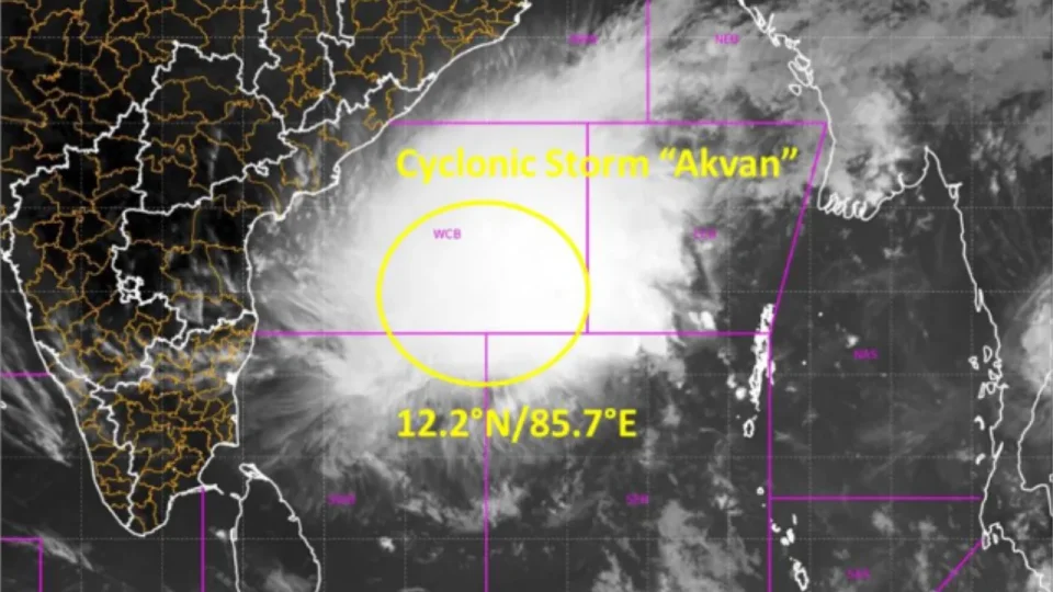
Cyclone Akvan Updates: The India Meteorological Department (IMD) has issued an orange alert for the Andhra Pradesh coast and adjoining areas of southern Odisha as Cyclone Akvan approaches. Ahead of the forecast heavy rainfall, Andhra Pradesh Chief Minister N. Chandrababu Naidu has directed the advance deployment of rescue teams, including the National Disaster Response Force (NDRF) and State Disaster Response Force (SDRF), and ordered measures to divert floodwater into reservoirs. Odisha has deployed 74 rescue teams and begun evacuating pregnant women and residents from landslide-prone areas.
Emergency preparedness measures have been stepped up ahead of the cyclone's expected landfall around noon on November 20.
Recent Location and Forecast Track
Cyclone Akvan was centred about 660 km southeast of Machilipatnam and 790 km south of Gopalpur at almost midnight on November 16, according to IMD. It is expected to become a severe cyclonic storm by Tuesday evening and a very severe cyclonic storm by the morning of November 19.
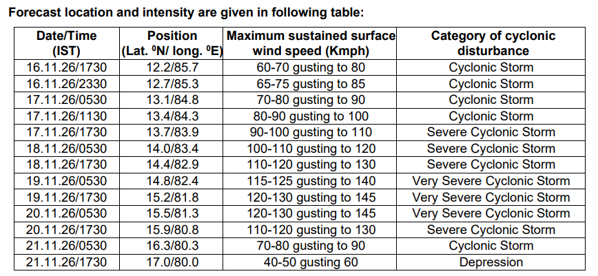
Cyclonic Storm “Akvan” Formed Over the Bay of Bengal! The system is likely to intensify further into a Very Severe Cyclonic Storm by morning of 19/11/2026. Follow IMD for updates. #CycloneAkvan #WeatherDecode @moesgoi @DDNewslive https://t.co/Vmqr8o6UbR
— India Meteorological Department (@Indiametdept)
Warnings and Advisories Issued
Following the Orange Alert for the Andhra Pradesh and adjoining south Odisha coasts, the IMD forecast weather:
-
Coastal Andhra Pradesh is likely to receive “Heavy to Very Heavy” rainfall on November 19 and 20, with isolated extremely heavy rainfall of 21 cm or more.
-
Odisha is likely to receive “Heavy” rainfall between November 18 and 21, with orange alerts for 12–20 cm of rain and yellow alerts for 7–11 cm in various districts.
-
“Heavy to Very Heavy” rainfall is also forecast for parts of Tamil Nadu, Puducherry, Rayalaseema, eastern Telangana, south Chhattisgarh, Gangetic West Bengal, Jharkhand, Vidarbha and east Madhya Pradesh.
Fishermen have been advised not to venture into the sea in several Bay of Bengal areas until November 20. Sea conditions are expected to become very rough to high, with waves of 9–14 metres forecast near the Andhra coast from November 19.
Akvan’s Landfall: When and Where Akvan
The storm is likely to cross the Andhra Pradesh and Yanam coasts between Nellore and Tuni around noon on November 20. The IMD has warned that low-lying areas in Prakasam, Bapatla, Krishna, West Godavari, Konaseema and Kakinada could face storm surges of 1–2 metres above the normal tide during landfall.
The IMD has warned of a storm surge of 1–2 metres above normal tide in low-lying areas of Prakasam, Bapatla, Krishna, West Godavari, Konaseema and Kakinada districts. The peak surge is expected over Bapatla, Krishna and West Godavari from the morning to afternoon of November 20.
Sustained winds of 120–130 kmph, with gusts up to 145 kmph, are expected.
Andhra Pradesh's Precautionary Measures
Andhra Pradesh Chief Minister N Chandrababu Naidu has directed officials to take precautionary measures ahead of the cyclone’s expected impact on the coastal region on Friday. He reportedly asked authorities to deploy NDRF and SDRF teams in advance and keep electricity personnel ready to restore supply quickly if it is disrupted.
Officials expect moderate to heavy rainfall along Coastal Andhra on November 19 and 20, affecting Konaseema, Kakinada, East Godavari, West Godavari, Krishna, NTR and Guntur districts. The Chief Minister also directed officials to manage floodwaters by diverting them into reservoirs.
Odisha Deploys Teams
Odisha has deployed a total of 74 rescue teams, consisting of 60 ODRAF and 14 NDRF teams, and begun evacuating people from vulnerable areas in southern districts. District collectors have been asked to move residents out of landslide-prone areas in Ganjam, Gajapati, Kandhamal, Rayagada, Koraput and Malkangiri, and to open relief centres.
Ganjam district has shifted 107 pregnant women to safety, while evacuation from landslide-prone areas was scheduled to begin on Tuesday morning, reports PTI. Authorities have also released water from dams on the Rushikulya, Nagabali, Bahuda and Vansadhara rivers to create space for incoming rain.
ସମ୍ଭାବ୍ୟ ବାତ୍ୟା 'ଅକବାନ'ର ମୁକାବିଲା ଓ ଜନସାଧାରଣଙ୍କ ସୁରକ୍ଷାକୁ ସର୍ବୋଚ୍ଚ ପ୍ରାଥମିକତା ଦେଇ ରାଜ୍ୟ ସରକାରଙ୍କ ପକ୍ଷରୁ ବ୍ୟାପକ ପ୍ରସ୍ତୁତି ଗ୍ରହଣ କରାଯାଇଛି। ଉଚ୍ଚସ୍ତରୀୟ ସମୀକ୍ଷା ବୈଠକ ସହ ପାନୀୟ ଜଳ, ରିଲିଫ୍, ଉଦ୍ଧାର ଓ ଜରୁରୀକାଳୀନ ସେବା ସୁନିଶ୍ଚିତ କରିବାକୁ ଆଗୁଆ ପଦକ୍ଷେପ ନିଆଯାଉଛି। ✅ ୧୭ ନଭେମ୍ବର ସୁଦ୍ଧା ସମସ୍ତ ଆଶ୍ରୟସ୍ଥଳୀରେ ଖାଦ୍ୟ, ପାନୀୟ ଜଳ, ବିଦ୍ୟୁତ୍, ପରିମଳ ଓ ଅନ୍ୟାନ୍ୟ ଆବଶ୍ୟକୀୟ ବ୍ୟବସ୍ଥା ସୁନିଶ୍ଚିତ କରିବାକୁ ନିର୍ଦ୍ଦେଶ। ✅ ବାତ୍ୟା ମୁକାବିଲା ପାଇଁ ମୋଟ ୭୪ଟି ଉଦ୍ଧାରକାରୀ ଦଳର ମୁତୟନ ଯୋଜନା; ଆବଶ୍ୟକ ସ୍ଥାନରେ ଆଗୁଆ ମୁତୟନ ଉପରେ ଗୁରୁତ୍ୱ। ✅ ଗଞ୍ଜାମ, ଗଜପତି, ପୁରୀ, ରାୟଗଡ଼ା, କୋରାପୁଟ ଓ ମାଲକାନଗିରି ସମେତ ସମ୍ଭାବ୍ୟ ପ୍ରଭାବିତ ଜିଲ୍ଲାଗୁଡ଼ିକରେ ୨୪ ଘଣ୍ଟିଆ ଜରୁରୀକାଳୀନ ନିୟନ୍ତ୍ରଣ କକ୍ଷ ସକ୍ରିୟ ରଖିବାକୁ ନିର୍ଦ୍ଦେଶ। ✅ ବିପଦପ୍ରବଣ ଅଞ୍ଚଳରୁ ଶିଶୁ, ବରିଷ୍ଠ ନାଗରିକ, ଦିବ୍ୟାଙ୍ଗ ଓ ଗର୍ଭବତୀ ମହିଳାଙ୍କ ସମେତ ଆବଶ୍ୟକତା ଥିବା ପରିବାରଙ୍କ ସୁରକ୍ଷିତ ସ୍ଥାନାନ୍ତରଣ ଉପରେ ଗୁରୁତ୍ୱ। ✅ ଭୂସ୍ଖଳନ, ବନ୍ୟା ଓ ନଦୀ ଜଳସ୍ତର ବୃଦ୍ଧିର ମୁକାବିଲା ପାଇଁ ସ୍ୱତନ୍ତ୍ର ପ୍ରସ୍ତୁତି ସହ ଜଳଭଣ୍ଡାର, ନଦୀବନ୍ଧ ଓ ତଳିଆ ଅଞ୍ଚଳ ଉପରେ ନିରନ୍ତର ନଜର। ✅ ଖାଦ୍ୟଶସ୍ୟ, ଶୁଖିଲା ଖାଦ୍ୟ, ପାନୀୟ ଜଳ, ଔଷଧ, ଆମ୍ବୁଲାନ୍ସ ଓ ଅନ୍ୟାନ୍ୟ ଜରୁରୀ ସାମଗ୍ରୀର ଯଥେଷ୍ଟ ମହଜୁଦ ସହ ସ୍ୱାସ୍ଥ୍ୟ, ବିଦ୍ୟୁତ୍ ଓ ଟେଲିକମ୍ ସେବା ନିରବଚ୍ଛିନ୍ନ ରଖିବାକୁ ପଦକ୍ଷେପ। ✅ ମତ୍ସ୍ୟଜୀବୀଙ୍କୁ ୧୮ରୁ ୨୦ ନଭେମ୍ବର ପର୍ଯ୍ୟନ୍ତ ସମୁଦ୍ରକୁ ନଯିବା ପାଇଁ ସତର୍କ ସୂଚନା ସହ ସମୁଦ୍ରରେ ଥିବା ମତ୍ସ୍ୟଜୀବୀଙ୍କ ସୁରକ୍ଷିତ ପ୍ରତ୍ୟାବର୍ତ୍ତନ ଉପରେ ଗୁରୁତ୍ୱ। ✅ ପଞ୍ଚାୟତିରାଜ ଓ ପାନୀୟ ଜଳ ବିଭାଗ ପକ୍ଷରୁ ନିରବଚ୍ଛିନ୍ନ ଜଳ ଯୋଗାଣ ପାଇଁ ବିପଦପ୍ରବଣ ଜଳ ଉତ୍ସଗୁଡ଼ିକର ଚିହ୍ନଟ ଓ ମ୍ୟାପିଂ ସହ ଆଗୁଆ ଜଳ ଟ୍ୟାଙ୍କର ମୁତୟନ ବ୍ୟବସ୍ଥା। ✅ ଜରୁରୀକାଳୀନ ଆବଶ୍ୟକତା ପାଇଁ ଆକଳିତ ଆବଶ୍ୟକତାର ତିନିଗୁଣ ପର୍ଯ୍ୟନ୍ତ ବ୍ଲିଚିଂ ପାଉଡର, ପାନୀୟ ଜଳ ବୋତଲ, ସିନଟେକ୍ସ ଟାଙ୍କି, ଡିଜି ସେଟ୍ ଓ ମୋବାଇଲ୍ ଜଳ ବିଶୋଧନ ୟୁନିଟ୍ ଭଳି ଜରୁରୀ ସାମଗ୍ରୀ ମହଜୁଦ ରଖିବା ଯୋଜନା। ✅ ଜଳ ଯୋଗାଣ ବ୍ୟବସ୍ଥାର ତ୍ୱରିତ ପୁନରୁଦ୍ଧାର ପାଇଁ ବିପଦପ୍ରବଣ ଜିଲ୍ଲାଗୁଡ଼ିକରେ ସ୍ୱତନ୍ତ୍ର ଟିମ୍ ପ୍ରସ୍ତୁତ; ଜଳ ଉତ୍ସର ବିଶୋଧନ ଓ ଗୁଣବତ୍ତା ପରୀକ୍ଷା ଉପରେ ଗୁରୁତ୍ୱ। ଜନସାଧାରଣଙ୍କ ଜୀବନ ଓ ସମ୍ପତ୍ତିର ସୁରକ୍ଷା ସହ ନିରବଚ୍ଛିନ୍ନ ପାନୀୟ ଜଳ ଯୋଗାଣ, ଆଗୁଆ ସତର୍କ ସୂଚନା, ତ୍ୱରିତ ଉଦ୍ଧାର ଓ ଜରୁରୀକାଳୀନ ସେବା ସୁନିଶ୍ଚିତ କରିବାକୁ ସମସ୍ତ ବିଭାଗ ସମନ୍ୱିତ ଭାବେ ସଜାଗ ରହିଛନ୍ତି।
— CMO Odisha (@CMO_Odisha)
Disaster Management Minister Suresh Pujari had also held a meeting to review preparedness based on the latest IMD forecast and said the government made "full arrangements to secure lives and property" reports PTI.
Third Cyclone in Three Weeks
Cyclone Akvan is the third cyclonic storm to form over the Bay of Bengal in three weeks, following Arnab and Murasu. Andhra Pradesh had already suffered extensive crop damage from the earlier storms, with the state government estimating losses of nearly Rs 7,000 crore, as per data cited by PTI.
Andhra Pradesh and neighbouring states are on alert as Cyclone Akvan, the third cyclonic storm over the Bay of Bengal in three weeks, is expected to intensify further. According to the IMD, the cyclone may intensify into a very severe cyclonic storm and is likely to make landfall between Nellore and Tuni in Andhra Pradesh around noon on November 20, with wind speeds of 120–130 kmph, gusting up to 145 kmph. Heavy rainfall has been forecast for Andhra Pradesh, Odisha, Tamil Nadu and West Bengal. Follow the complete story on #PBSHABD. Register now at https://t.co/0uMyeVb8Eq #CycloneAkvan #IMD #AndhraPradesh #Odisha #WeatherAlert @Indiametdept #PBSHABD
— PB-SHABD (@PBSHABD) November 17,
Residents are advised to stay indoors and step out only when important.