When and Where Will Cyclone Arnab Make Landfall? Know What IMD Says
IMD issues a Red Message as deep depression intensifies into Cyclone Arnab; landfall expected between Bapatla and Visakhapatnam on Oct 28 with winds up to 140 km/h.
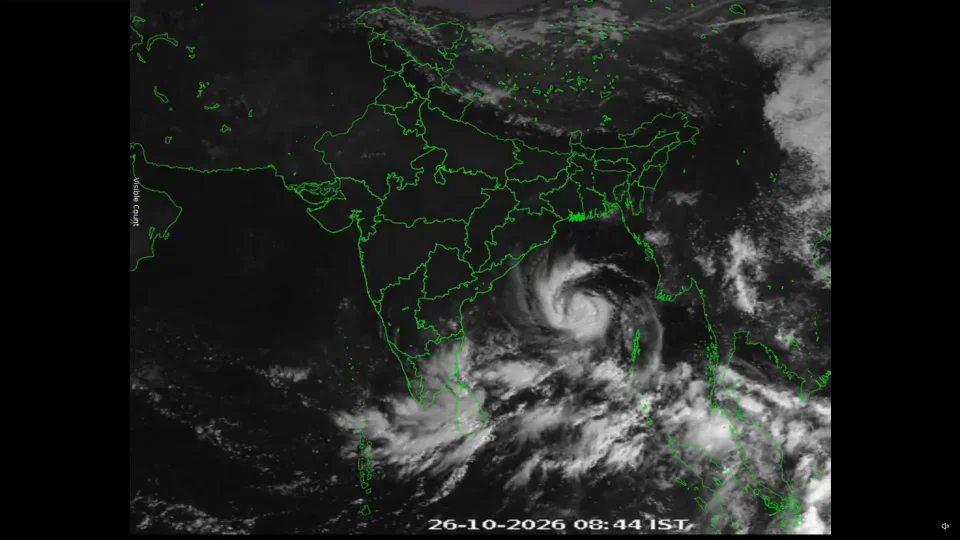
Cyclone Arnab news: The Indian Meteorological Department (IMD) on Monday informed that a deep depression in the Bay of Bengal is moving west-northwestwards and is currently closest to Gopalpur, Odisha. The storm is currently intensifying and is expected to transform into Cyclone Arnab by midnight. It will further intensify in the same region by tomorrow, October 27. Besides Odisha, Andhra Pradesh and the Andaman Islands will see the impact of the deepening storm. In view of the constant sea activity, state governments have deployed rescue teams and announced the closure of schools and colleges.
“It is very likely to move west-northwestwards and intensify further into a severe cyclonic storm over westcentral Bay of Bengal by midnight of today, the 26th October and into a very severe cyclonic storm over the same region on 27th October,” the IMD said.
Meanwhile, the IMD has issued a Red Message cyclone warning for the Andhra Pradesh and adjoining south Odisha coasts, alerting residents about Cyclone Arnab and advising them to take precautionary measures, remain indoors, and close schools on the forecast dates. Concerned officials and personnel have also been asked to remain prepared for the possible cyclonic storm.
A red warning has been issued for five districts of Odisha for October 28, with very heavy rainfall and isolated extremely heavy downpours exceeding 20 cm forecast.
Odisha’s Precautions in Response to the Red Message
Chief Minister Mohan Charan Majhi instructed departments to prioritise public safety and evacuation, with the aim of preventing harm to locals.
A total of 302 rescue teams have been prepared for rescue and relief operations.
The Odisha government ordered the closure of schools, colleges, and Anganwadi centres in the districts of Ganjam, Gajapati, Rayagada, Koraput, and Malkangiri on October 28 and 29.
Around 60 Odisha Disaster Rapid Action Force (ODRAF) teams, 17 National Disaster Response Force (NDRF) teams, and 225 Fire Services units have been deployed to handle emergencies.
Evacuation of people from low-lying areas to safe shelters and the shifting of pregnant women and patients to healthcare facilities have been instructed. Health centres in potentially affected areas have also been directed to maintain adequate stocks of anti-snake venom injections, essential medicines, and medical kits.
Sub:Cyclonic Storm “Arnab” [Pronunciation: Ornab] over Eastcentral and adjoining Westcentral Bay of Bengal [Cyclone Warning for Andhra Pradesh and adjoining South Odisha coasts—Red Message]* The cyclonic storm *““Arnab” [Pronunciation :Ornab]”*over Eastcentral and adjoining Westcentral Bay of Bengal moved westwards with a speed of 15 kmph during last 6 hours, lay centered at 0830 hrs IST of today, the 26th October, 2026 over the same region near latitude 15.4°N and longitude 88.5°E, 580 km southeast of Gopalpur (Odisha), 610 km east-southeast of Vishakhapatnam (Andhra Pradesh), 620 km northwest of Sri Vijaya Puram (Andaman Islands), 690 km east-southeast of Kakinada (Andhra Pradesh), 790 km east-southeast of Machilipatnam (Andhra Pradesh) and 860 km east-southeast of Bapatla (Andhra Pradesh). It is very likely to move west-northwestwards and intensify further into a severe cyclonic storm over westcentral Bay of Bengal by midnight of today, the 26th October and into a very severe cyclonic storm over the same region on 27th October. Thereafter, it is very likely to move northwestwards and cross Andhra Pradesh & Yanam coasts between Bapatla and Visakhapatnam close to Yanam as a very severe cyclonic storm with the maximum sustained wind speed of 115-125 kmph gusting to 140 kmph by forenoon of 28th October, 2026.
— India Meteorological Department (@Indiametdept) October 26, 2026
Andhra Pradesh Chief Minister’s Directions to Officials
APSDMA (State Disaster Management Authority) has issued a set of guidelines and precautionary measures for the public.
Chief Minister N. Chandrababu Naidu directed officials to stay on high alert, coordinate emergency operations, issue regular public warnings, and ensure complete preparedness to reduce the cyclone’s impact. District-level control rooms are to be set up, precautionary messages sent to citizens' mobile phones, and coastal residents persuaded to follow government advisories.
Ten NDRF and eleven SDRF teams are prepared for rescue and relief work.
The CM directed officials to base preparedness measures on satellite information and scientific data, stressing that loss of life must be prevented and damage to property minimised as far as possible. Fishing boats have been instructed to return to shore, and fishermen have been advised not to venture into the sea because of extremely rough sea conditions.
Pregnant women expected to deliver during the coming week are to be shifted to hospitals in advance, as transport may be disrupted during the cyclone. Authorities are directed to maintain adequate stocks of drinking water and food, ensure funds for emergency arrangements, and keep relief and rehabilitation centres properly equipped. Mobile network agencies must be ready to restore services immediately if networks are disrupted; delays will not be tolerated.
How Cyclone Arnab Formed
A "Deep Depression" over the Bay of Bengal started moving westwards at a speed of 8 km/h for 6 hours until 5:30 PM on 25 October, when it lay centered around Latitude 15.1°N and Longitude 90.5°E, about 450 km north-northwest of the Andaman Islands.
Movement and Forecast
The cyclone’s movement was forecast westwards with intensification into a cyclonic storm by the early morning of 26 October, and then into a severe cyclonic storm over the west-central Bay of Bengal by the morning of 27 October.
It stated that the intensified storm is likely to cross the Andhra Pradesh and Yanam coasts with a maximum sustained wind speed of 115–125 km/h gusting to 140 km/h by the forenoon of 28th October, 2026.
The IMD further forecasts the cyclonic storm’s landfall location on the Andhra Pradesh coast to be between Bapatla and Visakhapatnam (close to Yanam) by the forenoon of Wednesday, October 28. It is expected to cross as a Very Severe Cyclonic Storm, with maximum sustained surface wind speeds of 115–125 km/h and gusts reaching up to 140 km/h during landfall.